Scenario Settings Specifications of Evacuation Scenarios
Four Scenarios are specified by two dimension: availability of early prediction and organization of evacuation. Each scenario is associated with one conditional probability of occurrence (more information).
General Model DesignBased on Jonkman’s framework, a conceptual model for the linked-modeling approach of victim estimation is proposed below. The model framework includes six major components by consideration of major flooding-evacuation process and major factors in victim estimation.
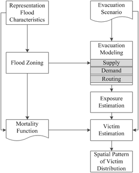
Conceptual Model of a Linked-Modeling Approach
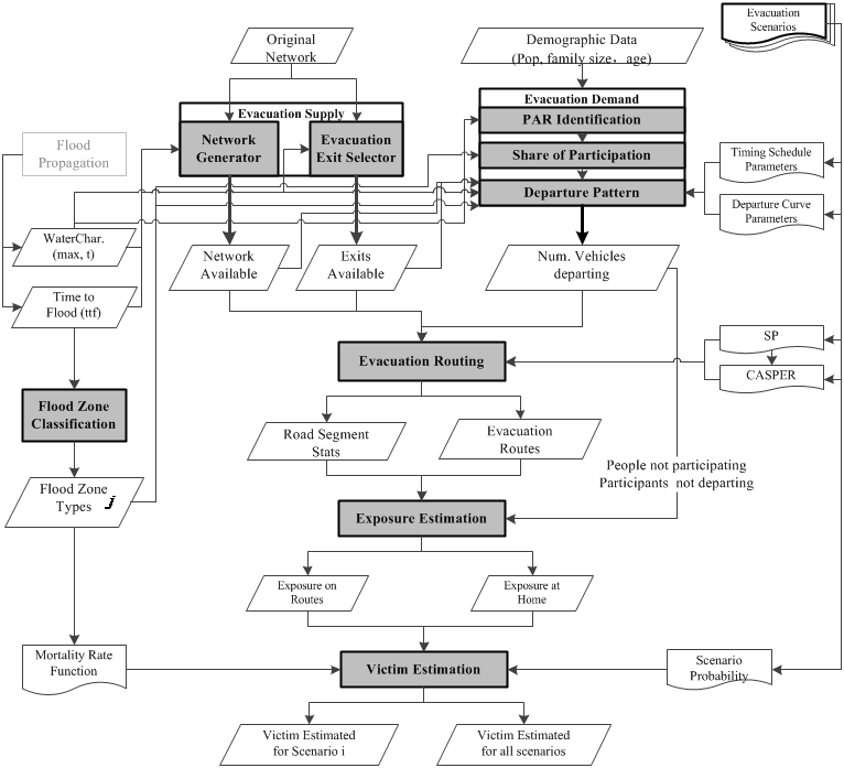
Elaborated Model Design
Modeling DocumentationsFollowing Documentations for building the linked flooding and evacuation model are accessible for academic and non-profit use, free of charge, provided the source acknowledged.
In addition, demo data could be shared and accessed in form of Geodatabase via Dropbox links. You can send a email to the author. |
Major Modeling Modules1. Flood Zone ClassificationBased on Jonkman et al.’s approach , for classification of flood zone types, flood characteristics are taken as the basic inputs and three types of flood zones are generated as outputs. (more information)
2. Victim EstimationAs shown in Figure 3‑3, different evacuation scenarios could be engaged with independent probabilities of occurrence. Different evacuation scenario would lead to varied settings about travel demand and evacuation routing, hence result in different estimation of number of victims. Thus, for one single incident of flood facing with uncertainty of evacuation process, the total estimated victims would be aggregated by summing up estimations for single scenarios weighted by scenario probabilities. (more information)
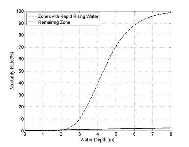
Mortality Rate Function Specification
3. Exposure EstimationThe component of exposure estimation gives estimation of population exposed to flood either at home or on the routes of evacuation. (more information)

EMS Data Structure and Exposure Identification
4. Evacuation routingThe very basic assumption of evacuation routing in this study is that all evacuees of each neighbourhood for each time instant only choose one evacuation exit and one optimal route. Under this assumption, a state-of-art network algorithm CASPER (Capacity-Aware-Shortest-Path-Evacuation-Routing) and a developed ArcGIS extension (ArcCASPER) are applied for evacuation routing. (more information)
5. Evacuation SupplyThis module includes modeling of two major components of infrastructure: road network and evacuation exits, by considering dynamic flood characteristics as primary impact factors. (more information)
6. Evacuation DemandEvacuation demand model is crucial for the whole evacuation modeling, as it provides fundamental information of people’s participation in evacuation and dynamic departure-pattern. Such information is directly used by evacuation routing and exposure estimation model. (more information)
|
